Map
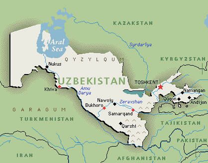
Uzbekistan is located between the two great Asian rivers the Amu Darya and Syr Darya, in the heart of Central Asia - a recognized geographical region in the south-west of the Asian continent and a natural bridge between Europe and the countries of Eastern Asia. This central position allows the country to be in both the northern and eastern hemispheres.
A look at the Uzbekistan map gives a clear idea about its immediate neighbors: Uzbekistan shares borders with Kazakhstan to the west and Kyrgyzstan to the north and Tajikistan to the east, and Afghanistan and Turkmenistan to the south.
Being one of the largest Central Asian states Uzbekistan covers an area of 447,400 square kilometers. It is the 56th largest country in the world by area and the 42nd by population (with population of more than 28 million people it is the most populous country in Central Asia).
Uzbekistan is divided into twelve provinces, one autonomous republic - Karakalpakstan, 162 districts. The country has 120 towns with major urban centres being Tashkent – the capital of the republic, Samarkand, Bukhara, Ferghana, and Khiva.